Home MX9
Maximize your large-scale mobile mapping projects with the Trimble MX90, offering superior GNSS performance in even the most demanding urban and rural environments, powered by the Trimble ProPoint® engine.
- Increased productivity and reduced field time.
- Enhanced data accuracy and reliability.
- Streamlined data processing and analysis.
- Cost-effective solution for large-scale projects.

Key
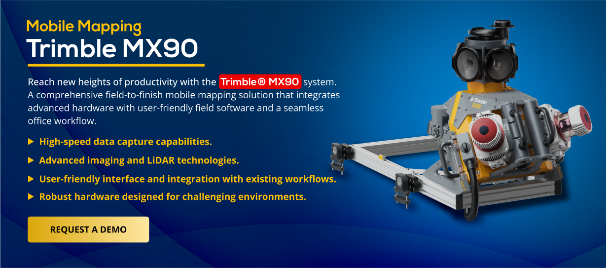
Features & Specifications
Features:
- High-speed data capture capabilities.
- Advanced imaging and LiDAR technologies.
- User-friendly interface and integration with existing workflows.
- Robust hardware designed for challenging environments.
Specifications:
- Laser effective measurement rate up to 3.6 MHz
- Spherical camera – 72 MP (6 x 12 MP)
- Planar cameras – 2 X 12 MP side facing, 1 X 12 MP backward/downward facing
- Inertial Measurement Unit (IMU) Enhanced GNSS precision
- Weight – Sensor unit 37 kg
- IP rating – Sensor unit IP64
- Scan speed – 500 scan/sec
- Embedded Trimble GNSS-inertial system – Trimble field-to-finish workflow
Effortlessly collect geospatial data by controlling data acquisition through any smart device. Easily adjust the lasers and oblique camera for optimal orientation.
Generate, inspect, and analyze high-quality survey, engineering CAD, and GIS deliverables by utilizing Trimble Business Center's data fusion capabilities.
Seamlessly integrate GNSS and inertial data for trajectory processing, using tightly coupled data in Trimble Business Center software.
Eliminate site revisits by sharing point clouds and images with overlaid existing asset data for collaborative workflows.
| Weight (Sensor Unit) | IP Rating (Sensor Unit) | Operating Temperature | Storage | |
|---|---|---|---|---|
| Trimble MX90 | 37 kg | IP64 | 0 °C to +40 °C | 2 x 4TB SSD removable |
| Trimble MX60 Core | 23.2 kg | IP64 | 0 °C to +40 °C | 2 x 4TB SSD removable |
| Trimble MX60 Pro | 25.4 kg | IP64 | 0 °C to +40 °C | 2 x 4TB SSD removable |
| Trimble MX60 Premium | 25.4 kg | IP64 | 0 °C to +40 °C | 2 x 4TB SSD removable |
| Trimble MX50 | 23 kg | IP64 | -10 °C to +50 °C | 2 x 2TB SSD / 4TB SSD |
| Trimble MX7 | 11.3 kg | IP65 | 0 °C to +35 °C | 2 TB SSD |
- Surveying & Mapping
- Oil & Gas
- Transportation Infrastructure
- Mining
- Utilities
- Public Safety & Forensics
Hear from happy customers who have already transformed their workflow with the MX90!
“As a Director of Remote Sensing, integrating the Trimble MX90 into our operations has been absolutely transformative. The team at AllTerra Central provided exceptional support throughout the entire process, offering expert training and seamless implementation. Their in-depth knowledge and hands-on approach enabled our team to quickly maximize the MX90’s capabilities, significantly enhancing our data collection efficiency and accuracy. It is a wealth of data, and new markets we have been able to go into because of the MX90.”